Showing posts with label development. Show all posts

31 May 2010

Holes in buildings: theories & practices

My urban theory reading group is getting into practice. A fortnight ago we joined the student occupation protesting cuts at Middlesex University and talked about Walter Benjamin, history and memory, 1968 and now. On Tuesday we engaged in a little more occupation of underused space - this time a mid-rise housing block standing empty awaiting demolition. Our reading: Eyal Weizman's Lethal Theory [PDF].


Lethal Theory explores Israeli Defence Force (IDF) tactics in Nablus, Palestine, April 2002. Palestinian resistance had barricaded all entrances to the old city and mined the roads, so the IDF gained access by "walking through walls" - that is, blasting holes in them and moving through the city using complex routes through Palestinians' homes, making the city not merely the site but the medium for urban warfare. This "microtactic" was conceived by the IDF's Operational Theory Research Institute in explicitly deleuzeandguattarian terms, such that the IDF would only defeat their enemy's classical, striated conception of space (ordered around roads, barricades, walls) through making the city 'smooth', borderless for their incursion.


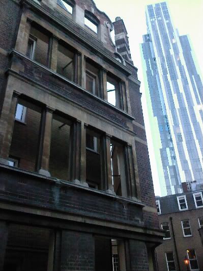
We walked into the block of flats through an open door. Up the stairs. A few flats were still inhabited, more sealed tight with heavy metal doors and window coverings. A handful though were open - completely open, without any doors and windows, inhabited by only fresh air and pigeons, topographically - as we had passed through no boundaries or barriers, just a series of passageways - still outside. (This, when vigilante security and then the police showed up, was our defence.)


The flats were almost empty. An old exercise book dated 2002, a benefits letter from 2003. A coathanger, a piece of string with pegs still attached.


The space felt wrong, uncanny. A bath shouldn't be on top of a bedstead. Wallpaper in the next room flapped in the wind, and pigeons nested in the ceiling cavities. Very literally unheimlich. The gaps where electricity cables and pipes had been ripped out to make the place uninhabitable. Homes are bodies to me. I didn't like that.

That's why the doors and windows had been removed too, we realised - to keep squatters out. The stairs had gone too, but we climbed.


I don't want to draw a parallel with what Weizman wrote; in fact, I'm trying to resist it. This isn't war, it's just housing redevelopment. The meaning isn't the same, the meaning isn't the same at all. I don't think the two situations are commensurable.

And yet... Why is the visual symbolism so similar? How far do these similarities continue through the very structure of these spaces? Points of contact:

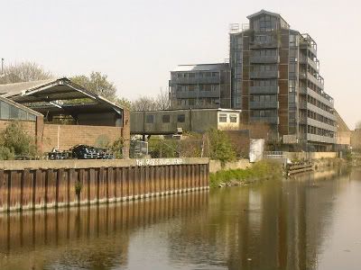
1. You've got the last few people living in the block and refusing to leave their homes despite the fact these are being made a wasteland. The effect on the outside of the building is violent, like missing teeth. It's a tactic of making a ruin in order to force people out (residents) and to make it impossible for them to stay securely (squatters).

2. This destruction of the "syntax of the city, ...the external doors, internal stairwells, and windows that constitute the order of buildings, this destruction that redefines inside and outside and refuses "to submit to the authority of conventional spatial boundaries and logic". (Weizman 2002: 53) This turning inside out seems a radical thing for power to do: "This was your home? That means nothing." Radical to do this topologically - the idea of home (in the Anglo-West) is predicated upon making a distinction between inside/outside in order to define private/public. It is a matter of borders and boundaries. The removal of windows and doors (the housing block) or walls (Nablus) makes these spaces merely a complex folding of outside space.

3. The intention of the building owners apparently "not to capture and hold ground" (2002: 56) but rather make it so permeable that no-one else can hold that space and turn it to their own uses or resist the development. These spaces windowless and breached do not even require IDF sensing technologies to "see through walls" - illicit occupants are visible from the street; these once-homes, formerly metaphorically Englishman castles, are now panoptical.

4. The developers are locking up some flats (thick green submarine doors, grey window sheaths) and opening out others - yet apparently for the same ends. (Why some flats get one treatment and others another, I'm unsure - but curious.) Similarly Weizman notes in an aside that, in their knocking-through, the IDF would still lock up Palestinian families in a single room and leave them there for days.

5. Difference: the IDF tactic is about letting Israeli soldiers pass through; the UK developer's tactic is about preventing squatters from staying. Nonetheless in both cases bulidings are not just the sites of these interventions but the very mediums, and the tactic is one of removal rather than addition - something counter to typical security thinking oriented around the encrustation of gates, locks, checkpoints, added barriers.

6. Power is enacted not just on space but on movement: enabling movement for the IDF; enforcing it for potential squatters to the housing block, for whom it is made impossible to stay.


Thus in two quite separate contexts of power acting on people's homes there is a strangely similar visual lanaguage (holes in walls), and three critical strategic similarities: building as medium; a tactic of removal; and power over not only space but movement.

What does these similarities mean? That is my burning question, and one I still can't quite answer for myself. Still, the quotation below is food for thought:

...address not only the materiality of the wall, but its very essence. Activities whose operational means effect the 'un-walling of the wall' thus destabilise not only the legal and social order, but democracy itself. With the wall no longer physically or conceptually sacred or legally impenetrable, the functional spatial syntax that it created - the separation between inside and outside, private and public, collapses. The very order of the city relies on the fantasy of a wall as stable, solid, and fixed.
(Weizman 2002: 75)

While quite arguably true for Nablus it's clearly too much for North London; nonetheless the point about spatial syntax holds true, and I wonder if these strange empty flats do something to the order of the city too. It brings to mind the 'broken windows' theory of crime writ large - if supposedly supportive council housing has such gaping wounds facing the street, how exactly can we expect some Manor House 13-year-old to believe that the destruction of property is a crime?

1. Credit to Adrian @cunabula for the topology insight.
2. Next reading group Wednesday 9th June, northeast London somewhere. If you're reading this you're welcome - drop me a line.

26 April 2010

Juxtapositions

or,
How to and how not to counterpose old & new architecture


This stands out as one of the nastiest mixings of old and new buildings I've ever seen. Take one historic facade (17th century?) on Gun Street, E1. Resentfully obey the letter of the listed building regulations, and do your damndest to flout the spirit of them. Knock down everything behind the facade and construct cheap-as-possible student housing in the kind of brick that'll be rotten in 40 years. Don't bother to align the windows, such that residents live in the dark and can only see three feet out on to the facade's concrete backing.

Meanwhile, in the background, a property developer constructs a new skyscraper according to formulae for maximising the floorplan at the lowest possible cost. The architects have no meaningful freedom, their only choice being how to whack on some "artfully asymmetric" cladding that enables the building to marketed as "designed" and "dynamic". In this way capital is over-leveraged, architecture constructed as a commodity, and lots more lovely capital (hopefully) accumulated.


In contrast, take this remarkably sympathetic use of materials for new-ish apartments on the River Lea near Bow. For once a block that was no-doubt marketed as having gritty urban-cool "warehouse" style actually has some dialogue with the dilapidated industrial buildings beside it. Ok, the form's nothing special. But just something in how the wood has weathered; the colour of the glass; the perforated steel balconies. Hemmed in on two sides by motorways (the A11 and A12), I can't promise that this is a genuinely functional, flourishing neighbourhood. When the old warehouses get knocked down for more new development, this fragile architectural sympathy between old and new will be lost. But for a few moments, on a sunny day in April...

5 March 2010

Modernism in Cansado, Mauritania - 1966, Architectural Digest

In a hotel and "cultural embassy" in the former dockland quarter of Amsterdam, I found old copies of Architectural Digest magazine from 1966, back when modernism was still modern.

I remember being surpised in urbanism school just how 'developing world' modernism really was. Paris may have been Haussmannised, but high modernism only got the chance to realise its urban masterplans in the places where city development was still somehow new - and planning legislation in its infancy. An April 1966 copy of Architectural Digest offered an amazing case study of this: from Mauritanian desert, from nowhere, the construction of a new town, called Cansado.


The magazine described it like this:

"In 1952 Milferma, a mining company, was formed to exploit the rich iron deposits in the Kedia d'Idjil mountains near Fort Gouraud. The considerable yield, in the region of six million ton a year, posed transport and administrative problems. A railway was built from Fort Gouraud to Port Etienne, 636 kilometres away, from where the ore could be shipped to Europe. Port Etienne, a makeshift conglomeration of fishermen's huts and military installations was suitable neither as a port nor as a town for the staff administering the port and railhead. It was decided therefore to plan a new town, Cansado, in the neighbourhood."


"Planning started in 1957. Homes for 5000 were to be provided in the first instance, though an eventual population of 35,000 was envisaged. The peninsula on which the new town was to be built is neatly divided between the north-south frontier between the Rio de Oro (Spanish Sahara) and Mauritania, but the coastline available, overlooking the great Levrier bay, was in any case the most protected and suitable for development. The whole consists of a soft and porous sandstone. There is no arable earth. Winds tear across the sandstone and sand erosion presents a considerable problem. Neither the temperatures nor the humidity are excessive. Rainfall is low. Dry winds are liable to cause discomfort from three to five months of the year (at its worst in August and September)."


"The nature of the site, the varied human and social forces, all have greatly affected the form of the development. Houses are oriented north-south, with few openings on the north. Materials have been chosen for their low thermal transmission. Buildings have been kept low to protect and shelter the site. But it is the different ethnic and social background of the inhabitants that has most marked the character of the town. The inhabitants of a wide and distinct origin have different needs. The Arab workers, for instance, wanted houses that allowed all domestic activity to centre around a courtyard that was altogether private. The administrative staff placed more emphasis on the need for cross-ventilation and a view. The whole was thus divided into various quarters, each with its own centre, which was related to the main one which is to be extended when the town is enlarged at a later stage."

"Seven hundred and fifty houses together with churches, mosques, schools and shops were built between 1961 and 1963. The structural system was the same for all houses - load-bearing outer walls of a lightweight aggregate concrete, identical tie beams and cross-beams, enabling all elements to be prefabricated in a temporary factory."


In the 50 years since it is hard to see how a town of 5,000 - let alone the proposed 35,000 - could prosper simply from a railhead, and a port. In this age of automation, where are the jobs? The trains running from Zouerat may perhaps be the longest in the world, but what that means is all that freight only requires one driver. Nonetheless, lafraque on Flickr shows that Cansardo's buildings are still gleaming white, and still apparently uninhabited:


There is another perspective on these places, you understand. First I found these words on the Wikipedia page for Zouérat, another modernist European oasis constructed at the other end of the rail line, in land. Perhaps they will be edited out by moderators seeking to preserve an objective tone. I want to keep them. Whoever wrote them - Mauritanian or not - I think they say something:

"Zouerat is born at the end of the 1950's from nothing, at the end of the Kedia's glacis. The raw materials is transported from Nouadhibou by trucks, on the same way than the future Mauritania railway. Its plan is clear and well ventilated. Three places are made for europeans workers, commanders and executives. All the europeans houses are air-conditionned and furnished.
...
A shanty town grows around and a wall is made to separate the two cities. It is called "mur de la honte" (wall of shame) by the zouerati. The lack of houses for the mauritanians workers has gone to build new flats between Zouerate and the Kediet.

The climate is dry (no mosquito), and the most displeasing is the sand wind.

In 1976, the polisario attacks. A lot of Europeans leave and do not comme back."

And now the Mauritanian coast is another kind of modern, a nodal point of another global trade not in mineral ores but in people. They are not only West Africans: The NY Times reported in 2008 of an Italian fishing trawler towed into Nouadhibou carrying 369 people trying to reach Europe who had come from a continent away: Sri Lanka, Afghanistan, Burma, India and Pakistan.

"A new route has opened up", the UN say. From South East Asia migrants fly to Dubai or Abu Dhabi, and thence to Addis Ababa. Then Ethiopian Airlines to Bamako in Mali, Ouagadougou in Burkina Faso, or Dakar in Senegal. Then to the ports: Nouadhibou, Conakry, Dakar, and the hope of the the porous points in the European border: the Canary islands; Ceuta & Melilla, Spanish enclaves in North Africa, now closely walled; the Italian island of Lampedusa.

Consequently the Global Detention Project note that:

"Mauritania operates one dedicated immigration detention centre in Nouadhibou, nicknamed “Guantanamito” by detainees, which has been sharply criticised for its poor conditions (USCRI 2009; Amnesty 2008a; CEAR 2008; WGAD 2008; Reuters 2006).
...
Spain’s involvement in establishing the detention centre has raised questions over which authority controls the facility. While the centre is officially managed by the Mauritanian National Security Service (NSS), it is not governed by any regulations applicable to detention centres in the country (Amnesty 2008a, p. 24). Rather, as stated by Mauritanian officials “clearly and emphatically” to a delegation from CEAR in October 2008, Mauritanian authorities perform their jobs at the express request of the Spanish government (ESW 2009).
...
The high number of migrants taken in on a monthly basis has led to severe overcrowding, as noted by several groups who visited in 2008 (Amnesty 2008a; CEAR 2008; WGAD 2008). According to Amnesty, in March 2008 there were 216 bunk beds spread throughout the former classrooms, although only three rooms were being used during their visit. The organization reported that during its visit “a group of 35 who had been expelled by Morocco were being held in a room measuring 8m by 5m, with bars at the windows, which contained 17 bunk beds” (Amnesty 2008a, p. 21)"

So. From high modernism, to a room of displaced people in disputed state space and 1 sq m per person.