12 August 2008

I live(d) in Blade Runner

Nothing special for the photograph today, but it gestures at something so central to my mythology of the City. For six months 06/07 I lived in Clerkenwell (aka sexy warehouse architect land) in a big council highrise full of more yuppies than council tenants. The area was... odd, actually, despite the hype. It was a little lacking in basic necessities such as a decent supermarket, hell, even just a newsagent open when I wanted the Sunday papers. A little too quiet after hours; it had City looks, but not City buzz. It didn't really feel homely, but nor did it feel anything else.

But one thing made up for all that. Up on the sixth floor balcony, walking towards my flat's front door, I had this view - the Barbican towers, their dark jagged concrete forms disjunct on the skyline. Not so close (about a kilometre away) and, on a sunny day, not so foreboding - but still a gift because they let me pretend, just for a few seconds as I walked towards the door, that I was living in Blade Runner. In my heart, that is what the City is about.

The City is Bananas

Today I finally caught up with my friend Astrid. We found some coffee then went hunting for banana skins - no really. Astrid runs London Bananas, a photoblog dedicated to the urban banana. A new(ish) resident of the City, she writes:

"When I arrived I noticed something straight away: there's a lot of banana skins around.
I see them everywhere. They're languishing on doorsteps, hanging out in the middle of the road, dangling off street signs, peeking out of piles of garbage, reclining in the middle of the sidewalk, riding the bus for free....
Eventually I managed to get a camera and started documenting these bananas in situ, partially because I thought it was funny and partially to assure myself that I wasn't making it up."


Here's one of her photos:


Why's this belong here? Because, like people on BoingBoing, I'm loving the game of 'guess where?' these photos inspire. Taken at banana-height perspective often without much background context, these pictures challenge my micro-knowledge of the City. I know where Astrid lives, works, goes drinking - but have I been concentrating? Can I place that shopfront, those railings, that advertising hoarding? I want to be able to do so: I want to know my City intimately, not (just) as theoretical structures and systems but like the palm of my hand. (Like my own body...)

And simultaneously London Bananas also functions as a guide to someone else's City, her paths and the traces these leave in her mind; a little awareness of the things she sees that I never do, that is, banana skins.

7 August 2008

Decorating the City

I love my shitty motorola camera-phone - sometimes it chooses to focus on things, sometimes it chooses not to. We shall pretend, please, that this random variation makes my photos on this blog more artistic, and that it's nothing to do with being too slothful to find/carry/use a proper camera!


By Old Street tube, 4 Aug 08. The tag -ACK (the first letter was damaged) made out of the genius new medium of plastic cups stuffed into wire net fencing.


20 Apr 08, probably East London. Stencilism by now outweighs spray-can graffiti, or at least the good stuff - wonder who to blame for that?! It still looks great, but yet is something of the soft & easy option, I think...


29 Jan 08 - pure Dada.

Gower Street, 28 Feb 08


Foucault wept.

Tate Modern 'Global Cities' exhibition

The Global Cities exhibition at the Tate Modern last summer was not a raving success. Rem Koolhaas talked bollocks about slum dwellers being 'more free' in their architectural choices because they weren't constrained by Evil Conservative Planners - the fact that they're constrained by lack of money and materials, which likewise generates stylistic uniformity, didn't seem to occur to him. Graphs appeared without scales or quantification, statistics without context and sometimes flat out wrong (a 10 km square is not the same as 10 square km, oh innumerate curator). And most of the video works were vague, uncontextualised, and a bit dull.

But I found some pictures on my phone of the cool stuff, so I thought I'd post them:


Nigel Coates (2007) Mixtacity
An artistic reading of urban planning for the Thames Gateway - brilliant because at first the only weirdness seemed to be that the buildings were made of biscuits & rolls of thread; then, as you looked further east, the buildings themselves got stranger and stranger, but so gradually that it all seemed plausible.


A plywood model of the residential density of a city, possibly Mumbia. Pretty but essentially meaningless, given that there's no scale attached. And can the city's borders really be so sharply defined, moing from ultra-dense to barely populated in the space of a kilometre or less? I doubt it. So what's the point of such an impressionistic rendering?


Not sure who this was - Planet of Slums is a Mike Davis phrase, but he wasn't a contributor. But as a signpost of increasing class segregation in the city, it's apt - makes me think of the vitriolic battles over hipster appropriation of Brooklyn, New York.

6 June 2008

Ur-points: Sim City


If it hadn't been for a childhood spent in a darkened room, hunched in front of genius early computer game Sim City, would I have ever got so interested in cities, their patterns, and the forces that shape their operation? The variables one could control in Sim City (taxes, land-use zoning, transport and so on) always functioned linearly-enough that the algorithms behind the game were semi-visible, making it (after enough practice) easy enough to build the optimum-functioning city. So after having built a profitable, thriving city, I had to seek new challenges - to design a city optimised for education, or low pollution, or of lots of separate small communities. This sounds not so far from the challenges of real urban planning, but when I tried to implement the Chicago school models of urban zoning I learnt about in GCSE geography, they never really worked. Sometimes I would get bored, and attack my cities with wave after wave of floods, fires, aliens, volcanoes... Or take profit-making to its logical conclusion and construct an ultra-dense city of arcologies, each holding thousands of Sim-residents - and ridden with crime, and so watched over by a thousand police stations...

These days, of course, I have read de Certeau and I know all about the importance of practice, I know about performed spaces and subaltern geographies and more. But still, those early days spent simulating cities force me to acknowledge the pleasures of the god-view, make it seem so easy to slip into pastel-coloured dreams of total knowledge, and order, and discipline, all for the welfare of the population...

Sensuo-city

The city stinks today, a cloying retch of decay. I believe it is only a type of tree pollen, but it still hints at the possibility of a dead body rotting in a flat overlooking the street, the dark & disgusting unknowns that might hide behind every wall in this space... It blends into the honk from the fishmongers - real dead bodies this time, blended with a slight hint of unwashed pussy... Jeez, when I dream of an embodied city I do not want my thoughts to go in this direction!

31 March 2008

HEFTED, or, Thinking Like A Sheep

The best upland sheep in Britain are 'hefted', a phenomenon where they are instinctually attached to a certain area of land. They know this land intimately: where's best to go when a storm hits, where the natural salt lick is found, and how heavily to graze the ground. This territorial knowledge is passed on from mother to lamb, and it's strong - Cumbrian farms may have a "landlord's flock" that has to be sold to stay with the farm, as if moved elsewhere the sheep will just walk over the fells back to their 'heaf'.

I find it interesting that this instinct was man-made - by shepherds in the 18th and 19th centuries. After the Acts of Enclosure, lowland grazing ground was divided into fields all owned by one person or another, but the Cumbrian fells were left as unfenced common-land. This provided a communal grazing resource, with rights given to
farmers to graze their sheep on individual sections. But the sheep could easily stray for miles - so the shepherds taught them to stay put. Through breeding their own flocks, and rearing lambs in exactly the same places year-on-year, farmers have maintained this hefted instinct for hundreds of years. These sheep belong.

This isn't a rural affairs blog, I know! But give me time and I'll explain why it's an interesting way of thinking about the spatial.
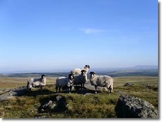


1. Foot and mouth disease in 2001 was disastrous for this way of farming. It disrupted traditional patterns of moving sheep between high and low ground, and a couple of seasons of lambs were born un-hefted - making them a liability to keep on the rugged fell-land. Consequences: this is really interesting for thinking about the timescales and durability of tradition. On one hand, hefting produced by shepherds 250 years ago has lasted. On the other, it's so easily disrupted...

I can also see a really good PhD proposal here! About the problems of government intervention into rural life not properly understood, and competing spatial knowledges - hefting versus the language of proximity and contamination of foot & mouth management. (When, in fact, there were other strategies for stopping foot & mouth, such as inoculation...)

2. Really good article in the Independent yesterday about declining rural people and ways of life:
Another country: whatever happened to rural England? - Richard Askwith

I then want to cross-reference it with this one in the Times: Are you hefted? If not, that's a pity - Ben Macintyre

The point of intersection: what about people being hefted? What would that entail?

There are clearly some similarities to the Welsh concept of hiraeth, longing or homesickness - the same instinctual desire to be in a particular place, and feeling rooted there. But hiraeth is a word more often used by sentimental Americans tracing their genealogies - I think 'hefted' is more rigorous. The Independent article mentions a farming woman, 83, who has only ever spent one night off her farm, and never been further than Exeter. Now that is being hefted.

I love and adore the City, and City life and streets and space, and refuse to take any future path that leads away... But that's not being hefted, that's not enough. I wasn't born here (few in the City are: it's a destination aspired to & chosen), my parents and grandparents before me weren't born here, and I keep moving between neighbourhoods of the City in search of a better flat! Perhaps the only heft I can claim is at the scale of England itself, not just in terms of inherited roots, but an instinct that's expressed very much in terms of relations to the landscape (the heath, the birch trees, the moor...) And a great-uncle, the last of the family to farm, who does indeed keep sheep on the the uplands of the Dales...

24 February 2008

WalkScore: Quantifying urban experience

WalkScore is a piece of genius that quantifies a neighbourhood's 'walkability'. Enter your street address or postcode, and it uses shop and amenity data from Google Maps to give your specific address a walkability score out of 100.

So what does this concept of 'walkability' entail? They say:
Walkable communities tend to have the following characteristics:

* A center: Walkable neighborhoods have a discernable center, whether it's a shopping district, a main street, or a public space.
* Density: The neighborhood is dense enough for local businesses to flourish and for public transportation to be cost effective.
* Mixed income, mixed use: Housing is provided for everyone who works in the neighborhood: young and old, singles and families, rich and poor. Businesses and residences are located near each other.
* Parks and public space: There are plenty of public places to gather and play.
* Accessibility: The neighborhood is accessible to everyone and has wheelchair access, plenty of benches with shade, sidewalks on all streets, etc.
* Well connected, speed controlled streets: Streets form a connected grid that improves traffic by providing many routes to any destination. Streets are narrow to control speed, and shaded by trees to protect pedestrians.
* Pedestrian-centric design: Buildings are placed close to the street to cater to foot traffic, with parking lots relegated to the back.
* Close schools and workplaces: Schools and workplaces are close enough that most residents can walk from their homes.

WalkScore

However, their algorithms are not this complex. (That'd be some pretty hardcore GIS!) Instead, they're working off Google Maps to assess the distances from a particular location to its nearest amenities, then combining these figures and finally ranking that location's cumulative walkable accessibility from 0 to 100, bad to good. This means it doesn't actually address most of the criteria of 'walkability' above. So is it any use - does it provide any assessment that makes real-life sense when compared with our own detailed, lived knowledge of places?

I'm impressed. I currently live in the City's northern inner suburbs in a nameless locale not quite part of half a dozen districts. My address gets a walkability score of 60, which I think bang on. 24-hr petrol station & grocery store 500m up the hill; a medium size Tescos 10 minutes walk a way, as is the tube. Bus stop outside the door, tailors and dry-cleaners 100m away, bank and library and coffee shops (aka civilisation) about 15 minutes up the hill and down again. Of course there are innumerable chicken'n'chips and pizza takeaways in walking distance - or should I say fat-arsed waddling distance? re. issues of obesity and food poverty - as easy access to cheap fried grease make up the very fabric of the City's 'burban fringes! But 60% walkable? I think so. Day-to-day maintenance is by-and-large local & walked - but for work, pleasure, socialising it's straight on the bus into Central.

Does me good. First place I've lived in this City that I've remained in for more than six to nine months...

...Though damn, yes, I still miss the yuppie student brat pad I shared in Bloomsbury a while back, affordable courtesy of a friend with a daddy who was 'something in mineral extraction'. Not quite up there with LSE's Russian oligarch-spawn and their penthouses in Covent Garden, but not miles away either... Walkability score 95% + Soho in 12 minutes = bliss.

Grew up on the edge of the City's commuter belt in a supposed market town that was more one big dormitory 'burb. Now, it's clear that Google Maps doesn't provide such good shops/amenities tagging outside the City - the library's not tagged, the sports centre's not tagged - and, more generally, there's a problem that newsagents don't seem to get tagged, when they're the standby saviour shop for residential areas. So perhaps the WalkScore for my childhood home of 5% is a little harsh - but shit, it felt that cut-off from any life, so I do not criticise too far!

My friend Ash: "I say keep hating your hometown: it encourages aspiration."

WalkScore currently works for the UK, the US and Canada - with more countries to be added soon. So give it a shot and tell me - how's its alogrithms compare to your subjective feel for your neighbourhood's walkability?

17 February 2008

Starting point I

Raban 1974 Soft City
Cities, unlike villages and small towns, are plastic by nature. We mold them in our images: they, in their turn, shape us by the resistance they offer when we try to impose our personal form on them. In this sense, it seems to me that living in cities is an art, and we need the vocabulary of art, of style, to describe the peculiar relationship between man and material that exists in the continual creative play of urban living.
(p. 2)

Both the villagers and the media sophisticates watched themselves living; they were all actors, and their performances were subject to a continual critical scrutiny. The studied gesture, the hand cupped around the igniting tip of the cigarette, the flounce of the caftan, the muddy stride across the Green, these were part of a calculated repertoire. To be part of the city, you needed a city style - an economic grammar of identity through which you could project yourself. Clearly this was something to be learned; an expertise, a code with clear conventions. If you could not get the surface right, what hope was there of expressing whatever lay beneath it? ... Some people dealt so finely in its niceties that they li
ved out a kind of vulgar poetry.
(p. 54)

Most of my acquaintances there had no real precedents for the life they were leading; they wanted to be 'in London' without knowing where London really was. And so they conspired to build a metropolis as glamorous, witty and up-to-date as the place they'd imagined as sixth formers in some small town or suburb.
(p. 55)